Help Research and Support the Response to Hurricane Irma

Help Research and Support the Response to Hurricane Irma

We need your help! If you have a few minutes, please read below.  

As Hurricane Irma bears down on Florida, hundreds, maybe thousands of organizations are preparing to descend upon the state to support the survivors. It is an effort that takes many different types of people from many different organizations. But who are these groups?  How do they find each other?  

These questions are the impetus for the Response Roster Project. We want to understand response efforts from the perspective of both the official and unofficial response. Who are the unsung heroes and responders taking time to help in any way they can?

Read More

Looking for My Virtual EM Conference Presentation?

Looking for My Virtual EM Conference Presentation?

A couple weeks ago I informed you that I was participating in my first virtual conference. I am happy to report the conference was a resounding success and I had many people attend my session on data, technology and social media for disaster management.  

Unfortunately, I know many of you could not make it. Don't fret!  Check out the recorded video below...

Read More

Feedback Needed on House Bill Proposing Social Media Research Project with Red Cross

Feedback Needed on House Bill Proposing Social Media Research Project with Red Cross

Representative Thompson from Mississippi introduced a bill to the House of Representatives for the American Red Cross (ARC) to conduct a pilot research project to better leverage social media in disasters. The language in the bill is fairly vague, but I gather they want the ARC to implement something tangible and then evaluate its usefulness and performance. 

A study like this could be very useful to the wider social media in emergency management (SMEM) community. I particularly like how the bill incorporates the use of social media to help deliver response supplies to affected areas, a form of operational intelligence. And social media for operations and intelligence is the next frontier of social media research that will enable disaster decision makers to make better decisions faster and more accurately.  

I will be providing feedback on this bill and am curious about others' thoughts. What other components of SMEM should be researched? Will this be useful to you? How so?

You can track the bill here. Here are the quick and dirty details of the bill: 

Read More

Are Disaster Infographics Still Cool? Useful?

Are Disaster Infographics Still Cool? Useful?

It seems like every week or month, I get "the latest" disaster infographic in my inbox. Inforgraphics have become popular in recent years to communicate complicated topics and data. There are infographics on social media, types of hazards, impact to businesses, emergency management careers, etc. I keep a Pinterest board for these types of graphics (see below).  

Because I am largely a curator of this information, not a consumer, I am not clear how infographics have helped the industry. Are disaster infographics useful? How have they helped? Are they effective? Have you used any in your work? If so, how?

Check out of a few of the infographics below and let me know what you think.

Read More

Exercising Social Media - Review of and Q&A with EMSocialSimulation

Exercising Social Media - Review of and Q&A with EMSocialSimulation

I was recently able to talk with both Corey Mulryan and Kyle McPhee from Hagerty Consulting, a well-known and fast growing emergency management consulting firm. Corey and Kyle have been leading an effort at Hagerty to develop a new social media exercise tool called EMSocialSimulation. This blog post contains a review of the tool as well as Hagerty's Q&A responses that provide additional information.  

EMSocialSimulation is a great social media simulation tool geared toward organizations and jurisdictions looking to train and exercise on beginner to intermediate social media capabilities at an affordable price. I was impressed...

Read More

Idiot's Guide to Reddit

Idiot's Guide to Reddit


In many cases, we all need the simplest possible explanation for something.  It is a fact of life that no matter how hard we try to "get it," we are stymied until we hear it explained to use like we are in elementary school.

This was the case for me not too long ago.  It happened to be for Reddit, "a type of online community where users vote on content to take part in a reddit community."  Call it a mental block or simply glazing over the obvious, I just couldn't wrap my head around this type of user community and how it could be used in general as well as for disaster management. 

I found two great videos that led me to my aha moment and succinctly explain what Reddit is and how it works:


The first time I experienced Reddit's prominence was in the aftermath of the Boston Marathon Bombings.  Reddit users upvoted article(s) that incorrectly identified a suspect.  This reporting was grossly negligent and contributed significantly to rumors that should never have gotten the attention they did.     


Read More

How You Can Help 'Crowdsource' Typhoon Yolanda Response (UPDATED)

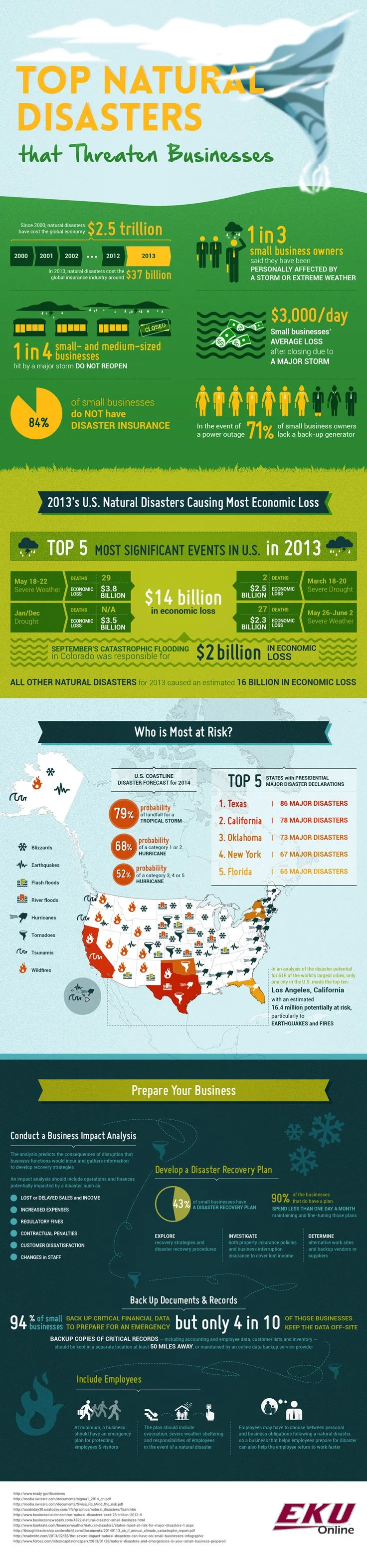
Update. This blog post has been updated since its original posting to provide additional background on MicroMappers' two primary initiatives (TweetClicker and ImageClicker) and provide additional explanation.  

Update 2. As of 9am Eastern on 11/13, no more Tweets and images are being added to the applications. However, you can still view results on the crisis map.

Typhoon Yolanda hit the Philippines this past Friday as one of the largest and most powerful storms ever recorded on earth. Many initiatives are underway to support response efforts. However, if you would like to support response efforts with your time and energy rather than donating, MicroMappers, at the request of the United Nations Office of Humanitarian Assistance (UN OCHA), has stood up two applications to help quickly identify ("tag") information from tweets and images relevant to disaster responders.

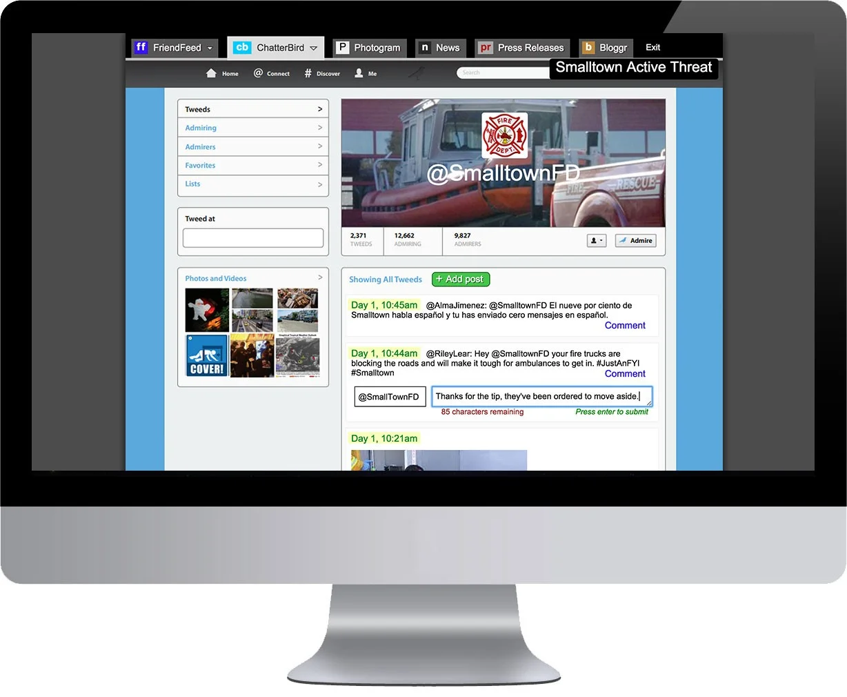
TweetClicker and ImageClicker are both simple to use "microtasking" applications to verify Tweets and images gathered from social media. The goal is to leverage the "crowd" to help sift through the massive amounts of data collected. Each application requires no technical expertise and can even be used on your computer or mobile device. The application runs you through  a simple tutorial before beginning. Each message takes about 3 seconds to review and will get reviewed by two other people, so your selections will be validated by others as well.

NOTE: If you encounter a "100% complete" notice when navigating to the pages, keep checking back every hour. The applications are adding new messages and images to verify continuously. 

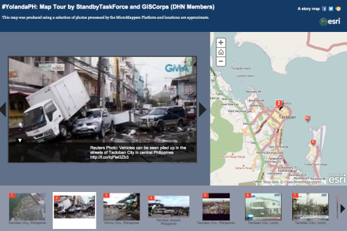
The results of this effort are being displayed on a live crisis map supported by the StandbyTaskForce and GISCorps, which are both members of the Digital Humanitarian Network. Each of these groups are network of people and organizations with missions to support the formal and informal response.

In the response to Hurricane Yolanda/Haiyan, they are digitally skilled volunteers acting as force multipliers. Conceptually, they are similar to Red Cross's Digital Operations Center that leverages digital volunteers to support response efforts. However, describing these organizations and how they operate is a separate post.

Leading this effort, though, is MicroMappers.  The initiative (loosely defined) is a partnership between QRCI, CrowdCrafting, and UN OCHA  and is led by a number of industry technologists including Patrick Meier, Ji Lucas, Luis, Daniel, Ariba Jahan, Christine Jackson, and Daniel Lombrana Gonzalez.

For more background and continuous updates on Typhoon Yolanda/Haiyan response efforts using TweetClicker and ImageClicker, check out this blog post.

White House Poised for Further Innovation with "Design Jam"

I had the distinct pleasure attending a White House design jam (think "design-a-thon") on Disaster Response and Recovery with over 90 colleagues from all over the tech and innovation space last Tuesday. Honorable mentions include MicrosoftGoogleNYC Digital, Twitter, Airbnb, Twilio, TopixLiquidSpace, Reddit, Rackspace, Palantir, DirectRelief, Recovers.org, APCO International, and Singularity University to name a few.  And yes, FEMA was there along with a couple White House Presidential Innovation Fellows!

Here is a quick description of the event:

The event, to be led by Todd Park, US Chief Technology Officer, and Richard Serino, Deputy Administrator of FEMA, will convene leaders in technology, design, academia, entrepreneurship, and philanthropy, as well as local and state officials to develop ideas for innovative solutions to emergency management challenges.
Participants will brainstorm creative new solutions and ways to support the development of prototypes for some of the best emerging ideas. Solutions will focus on: empowering disaster survivors; enhancing the ability of first responders as well as Federal, state and local officials to conduct critical recovery and restoration activities; and supporting integrated, whole-community efforts to better prevent, protect, mitigate, respond to, and recover from disasters.

We spent most of the day "jamming" to not just discuss, but actually create designs.  We worked through a cycle that included problem definition, design & build, test & evaluate, and iterate.  At the end of the day, we chose team captains to spearhead ongoing development efforts.

There were a number of fabulous projects that, if continued, could really help us leap frog forward.  Here are a few:

  • DisasterRSS - Creation of a "disaster.txt" publishing standard & ontology for websites (like RSS for blogs).  This simple idea is for any organization that has data or information useful in disasters.  The organization would create a .txt file on its website that would have all relevant information for data geeks and others to access its data.  Here is a very basic example.
  • SMS Survivor Survey - Designed to get specific information from specific population groups, the simple prototype simulated sending a short text message survey to a list of durable equipment owners with a tree of questions asking for their current location and the battery needs for their life-saving medical devices.  That information is then saved for disaster responders to deliver aid for the folks that need it.  This model can be adapted to a variety of use cases .  Check it out by texting (415) 236-3575.
  • Disaster Response Data Interchange - Geographically aware data interchange that will intelligently aggregate disaster recovery information from social media and other sites. The system will include Customer Relationship Management (CRM) functionality to autonomously engage “customers” to connect the “haves” with the “wants” across multiple sites. Additionally, it will have an Application Programming Interface (API) that will allow third parties to push/pull information automatically into and out of the data interchange.
The big question on many peoples' minds, though, is "so what's next?"  Innovative ideas are simply not enough to leap frog us forward.  We need action-oriented and sustainable projects supported by a correctly aligned policy and operational environment.  Additionally, resources including funding and expertise are also needed.  While these sentiments were echoed throughout the day, this may take time to realize.  I am hopeful as we push forward and the "design jam" format certainly seemed to be pushing us in this direction.

Check out the full Storify here.

So what is your opinion on what we need to go from innovative ideas to action and sustainability?

Smartphone Apps, the Next Step for Emergency Management?

I love the idea of mobile first strategy when it comes to applications. We are increasingly virtual and need the flexibility our phones offer to input and receive relevant information.My question, though, is is a mobile application by jurisdiction the best way to go since the public and other citizen responders are not bounded by jurisdiction, but rather geography?

Hurricane #Sandy Geotagged Social Media Maps w/Photos...Thanks @Geofeedia!

Geofeedia is releasing a number of regional maps that aggregate geotagged social media such as photos and videos on a map.  I highly recommend checking this out for real time visual information. Here is the message from Geofeedia...

Since the storm is expected to hit a large geographic area, we have created several regional Geofeeds which should help you to hone in on your particular areas of interest.

Here are a couple of other hints and suggestions as you cover the storm:

1. Draw your own smaller, more-targeted Geofeeds. These will leverage the data Geofeedia is already discovering in the background.

2. Want to see more photos? Turn off Twitter under the settings menu. There are A LOT of photos, but the significant volume of tweets can sometimes push them down in the queue.

Westchester and Fairfield Counties, New York

Staten Island and Jersey City

Manhattan

New York Boroughs

Philadelphia and Atlantic City

Ocean City and Cape May, NJ

Norfolk and Virginia Beach, VA

To all of our customers and friends on the East Coast, good luck and stay safe.

Best regards,

The Geofeedia Team